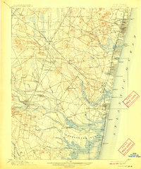
1901 Map of Asbury Park
USGS Topo · Published 1909About this map
The Jersey Shore coast between the Shark River Inlet and the Metedeconk Neck is a landscape of established seaside resorts and inland farming hamlets at the dawn of the twentieth century. While coastal towns like Asbury Park, Ocean Grove, and Bradley Beach are densely settled, the interior remains defined by small hubs like Farmingdale and Allaire. The area’s economic life is tied to the coast and the water, visible in the chain of life-saving stations, including L.S. Station Squan Beach and L.S. Station Mantoloking, which guarded the treacherous Atlantic shoreline.
Find a feature on this map
113 named features on this map. Tap any name to fly to it.
Don’t see what you’re looking for? This feature index may not catch every label — zoom into the map to look around manually.
Map Details
Editions of this 1901 Asbury Park Map
5 editions found

Other maps of this area

1884 · Whitings
USGS Topo · 1:62,500

1888 · Barnegat
USGS Topo · 1:62,500

1888 · New Brunswick
USGS Topo · 1:62,500

1888 · Asbury Park
USGS Topo · 1:62,500

1888 · Cassville
USGS Topo · 1:62,500

1888 · Sandy Hook
USGS Topo · 1:62,500

1888 · Whitings
USGS Topo · 1:62,500

1893 · New Brunswick
USGS Topo · 1:62,500

1893 · Sandy Hook
USGS Topo · 1:62,500

1893 · Asbury Park
USGS Topo · 1:62,500