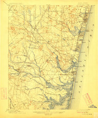
1901 Map of Asbury Park
USGS Topo · Published 1912About this map
The Jersey Shore's early 20th-century development is on full display here, showing the dense coastal clusters of Asbury Park, Ocean Grove, and Belmar before they merged into a continuous corridor. Inland, the landscape retains its rural character, defined by small farm settlements like Seven Stars, Ardena, and Farmingdale. The intricate network of waterways, including the Manasquan River and the sprawling Metedeconk River system, illustrates how the geography of the Manasquan and Shark River inlets shaped local commerce and recreation.
Find a feature on this map
111 named features on this map. Tap any name to fly to it.
Don’t see what you’re looking for? This feature index may not catch every label — zoom into the map to look around manually.
Map Details
Editions of this 1901 Asbury Park Map
5 editions found

Other maps of this area

1884 · Whitings
USGS Topo · 1:62,500

1888 · Barnegat
USGS Topo · 1:62,500

1888 · New Brunswick
USGS Topo · 1:62,500

1888 · Asbury Park
USGS Topo · 1:62,500

1888 · Cassville
USGS Topo · 1:62,500

1888 · Sandy Hook
USGS Topo · 1:62,500

1888 · Whitings
USGS Topo · 1:62,500

1893 · New Brunswick
USGS Topo · 1:62,500

1893 · Sandy Hook
USGS Topo · 1:62,500

1893 · Asbury Park
USGS Topo · 1:62,500