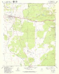
1979 Map of Ash Fork
USGS Topo · Published 1979About this map
Ash Fork serves as the central hub of this late-1970s landscape, positioned at a critical junction of the Atchison Topeka and Santa Fe railroad. The settlement is well-documented with local landmarks like the High Sch, a local Cem, and the nearby Ash Fork Landing Strip. The surrounding terrain within the Kaibab National Forest reveals an economy tied to both transportation and resource extraction, evidenced by an Old Railroad Grade and numerous Cinder Pits scattered across the volcanic landscape.
Find a feature on this map
48 named features on this map. Tap any name to fly to it.
Don’t see what you’re looking for? This feature index may not catch every label — zoom into the map to look around manually.
Map Details
Editions of this 1979 Ash Fork Map
3 editions found
Other maps of this area

1886 · Chino
USGS Topo · 1:250,000

1891 · Chino
USGS Topo · 1:250,000

1922 · Williams
USGS Topo · 1:125,000

1947 · Ash Fork
USGS Topo · 1:62,500

1947 · Picacho Butte
USGS Topo · 1:62,500

1948 · Ash Fork
USGS Topo · 1:63,360

1948 · Williams
USGS Topo · 1:250,000

1948 · Picacho Butte
USGS Topo · 1:63,360

1949 · Ash Fork
USGS Topo · 1:62,500

1950 · Picacho Butte
USGS Topo · 1:62,500