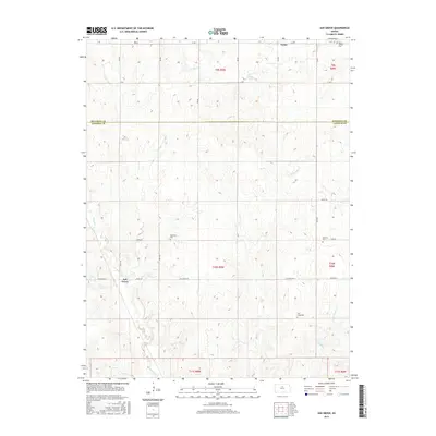
2015 Map of Ash Grove
USGS Topo · Published 2015About this map
Victor and Ash Grove anchor this prairie landscape along the border of Mitchell and Lincoln counties. The terrain is defined by a dense network of drainage systems, including the serpentine paths of Rattlesnake Cr and Bacon Cr, which carve through the Kansas plains. This survey provides a precise look at the rural infrastructure of the early 21st century, where local travel relies on a grid of secondary roads such as Vine Dr, Ash Grove Rd, and Wheat Dr.
Find a feature on this map
25 named features on this map. Tap any name to fly to it.
Don’t see what you’re looking for? This feature index may not catch every label — zoom into the map to look around manually.
Map Details
Editions of this 2015 Ash Grove Map
This is the sole edition of this map. No revisions or reprints were ever made.
Other maps of this area

1894 · Beloit
USGS Topo · 1:125,000

1955 · Beloit
USGS Topo · 1:250,000

1959 · Beloit
USGS Topo · 1:250,000

1962 · Vesper
USGS Topo · 1:24,000

1962 · Lincoln
USGS Topo · 1:24,000

1963 · Sylvan Grove
USGS Topo · 1:24,000

1967 · Hunter
USGS Topo · 1:24,000

1968 · Beloit SW
USGS Topo · 1:24,000

1968 · Lincoln NW
USGS Topo · 1:24,000
1968 · Ash Grove
USGS Topo · 1:24,000