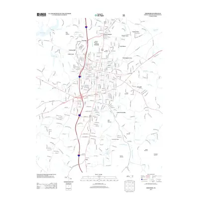
2013 Map of Asheboro
USGS Topo · Published 2013About this map
North Asheboro and its surrounding residential developments anchor the northern portion of this Randolph County landscape, where suburban expansion meets the varied terrain of the Uwharrie foothills. The map reveals a transition from dense neighborhood clusters like Westridge, Redding Hills, and Winningham Farm to the more open, mountainous spaces in the south and west. Water is a defining element throughout the quadrangle, ranging from the broad Back Creek Lake and Cedarwood Lake to the meandering Little River, which threads through the southern half of the sheet toward Ulah. The topography is marked by a series of prominent peaks and ridges, including Back Creek Mountain, Stack Rock Mountain, and the ominously named Purgatory Mountain. These landmarks, along with many smaller family-named features like Harveys Mountain and Cox Mountain, reflect the local history and geological character of this central North Carolina region.
Find a feature on this map
45 named features on this map. Tap any name to fly to it.
Don’t see what you’re looking for? This feature index may not catch every label — zoom into the map to look around manually.
Map Details
Editions of this 2013 Asheboro Map
This is the sole edition of this map. No revisions or reprints were ever made.
Other maps of this area

1953 · Raleigh
USGS Topo · 1:250,000

1954 · Raleigh
USGS Topo · 1:250,000

1957 · Asheboro
USGS Topo · 1:62,500

1968 · Ramseur
USGS Topo · 1:24,000

1968 · Erect
USGS Topo · 1:24,000

1970 · Randleman
USGS Topo · 1:24,000
1970 · Glenola
USGS Topo · 1:24,000

1970 · Asheboro
USGS Topo · 1:24,000
1973 · Eleazer
USGS Topo · 1:24,000

1973 · Seagrove
USGS Topo · 1:24,000