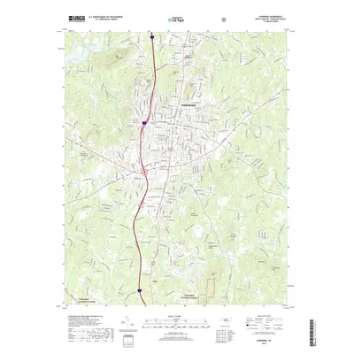
2019 Map of Asheboro
USGS Topo · Published 2019About this map
Asheboro and its surrounding heights dominate this 2019 survey, revealing a landscape defined by prominent peaks like Hedrick Mtn, Oakie Mtn, and Stack Rock Mtn. The Norfolk Southern railroad line cuts through the heart of the city, while Zoo Pkwy leads south toward the rugged reaches of the Uwharrie National Forest. This modern record preserves the locations of vital community landmarks, including the Old City Cem and Mount Calvary Cem, alongside regional infrastructure like the Asheboro Airport.
Find a feature on this map
63 named features on this map. Tap any name to fly to it.
Don’t see what you’re looking for? This feature index may not catch every label — zoom into the map to look around manually.
Map Details
Editions of this 2019 Asheboro Map
This is the sole edition of this map. No revisions or reprints were ever made.
Other maps of this area

1953 · Raleigh
USGS Topo · 1:250,000

1954 · Raleigh
USGS Topo · 1:250,000

1957 · Asheboro
USGS Topo · 1:62,500

1968 · Ramseur
USGS Topo · 1:24,000

1968 · Erect
USGS Topo · 1:24,000

1970 · Randleman
USGS Topo · 1:24,000
1970 · Glenola
USGS Topo · 1:24,000

1970 · Asheboro
USGS Topo · 1:24,000
1973 · Eleazer
USGS Topo · 1:24,000

1973 · Seagrove
USGS Topo · 1:24,000