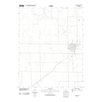
2009 Map of Ashland
USGS Topo · Published 2009About this map
The town of Ashland serves as the central hub of this Clark County landscape, showing a structured grid of streets including Kentucky St, Grant St, and Santa Fe. The town is flanked by essential community landmarks such as the Clark County Fairgrounds to the west and the Harold Krier Field to the south. The surrounding terrain is defined by a dendritic network of waterways, most notably the winding paths of Redhole Creek, Little Sandy Creek, and Bear Creek.
Find a feature on this map
30 named features on this map. Tap any name to fly to it.
Don’t see what you’re looking for? This feature index may not catch every label — zoom into the map to look around manually.
Map Details
Editions of this 2009 Ashland Map
This is the sole edition of this map. No revisions or reprints were ever made.
Other maps of this area

1894 · Sitka
USGS Topo · 1:62,500

1896 · Ashland
USGS Topo · 1:125,000

1955 · Pratt
USGS Topo · 1:250,000

1959 · Pratt
USGS Topo · 1:250,000

1972 · Ashland NW
USGS Topo · 1:24,000
1972 · Englewood
USGS Topo · 1:24,000
1972 · Ashland SE
USGS Topo · 1:24,000
1972 · Ashland
USGS Topo · 1:24,000

1979 · Sitka
USGS Topo · 1:24,000

1979 · Bloom SE
USGS Topo · 1:24,000