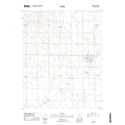
2018 Map of Ashland
USGS Topo · Published 2018About this map
Ashland serves as the focal point of this Clark County landscape, its grid defined by streets like Main St, Kentucky St, and Oak St. The town sits south of several drainage networks that define the local topography, including W Br Bear Cr and E Br Bear Cr, which converge as they flow toward the southeast. To the northeast, the terrain rises toward Mt Casino, a prominent high point overlooking Casino Cr. Just south of the main settlement lies Harold Krier Field, while the southern reaches of the map are marked by the winding paths of Little Sandy Cr and Redhole Cr. The road network is primarily composed of section-line county roads and Highway 160, which cuts through the heart of the region. This 2018 survey reveals the persistent agricultural and ranching layout of the High Plains, where watercourses like Spring Cr remain the primary geographical markers.
Find a feature on this map
53 named features on this map. Tap any name to fly to it.
Don’t see what you’re looking for? This feature index may not catch every label — zoom into the map to look around manually.
Map Details
Editions of this 2018 Ashland Map
This is the sole edition of this map. No revisions or reprints were ever made.
Other maps of this area

1894 · Sitka
USGS Topo · 1:62,500

1896 · Ashland
USGS Topo · 1:125,000

1955 · Pratt
USGS Topo · 1:250,000

1959 · Pratt
USGS Topo · 1:250,000

1972 · Ashland NW
USGS Topo · 1:24,000
1972 · Englewood
USGS Topo · 1:24,000
1972 · Ashland SE
USGS Topo · 1:24,000
1972 · Ashland
USGS Topo · 1:24,000

1979 · Sitka
USGS Topo · 1:24,000

1979 · Bloom SE
USGS Topo · 1:24,000