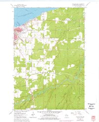
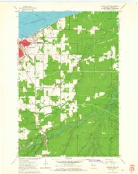
1964 Map of Ashland East
USGS Topo · Published 1976About this map
Ashland sits at the edge of Chequamegon Bay in this mid-century survey, revealing a landscape defined by its educational institutions and maritime industrial connections. The map highlights the academic footprint of Northland College and the County Teachers College, alongside several local schools such as Bay City Sch and Lake Shore Sch. The presence of the Soo Line and Chicago and North Western railroads indicates a busy regional transit network, while the southern reaches show the winding path of the White River through the township of Gingles. The inclusion of a Drive-in Theater and Trailer Park near the waterfront reflects the era's mid-century automotive culture and seasonal recreation patterns common to Lake Superior's south shore.
Find a feature on this map
38 named features on this map. Tap any name to fly to it.
Don’t see what you’re looking for? This feature index may not catch every label — zoom into the map to look around manually.
Map Details
Editions of this 1964 Ashland East Map
2 editions found
Other maps of this area

1942 · Ashland
USGS Topo · 1:48,000

1942 · Mellen
USGS Topo · 1:48,000

1942 · Marengo
USGS Topo · 1:48,000

1943 · Odanah
USGS Topo · 1:48,000

1945 · Odanah
USGS Topo · 1:48,000

1945 · Marengo
USGS Topo · 1:48,000

1945 · Mellen
USGS Topo · 1:48,000

1947 · Ashland
USGS Topo · 1:48,000

1953 · Ashland
USGS Topo · 1:250,000

1958 · Ashland
USGS Topo · 1:250,000