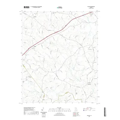
2020 Map of Ashland
USGS Topo · Published 2020About this map
Cromers Mill Covered Bridge stands as a significant landmark in the southern reaches of this Georgia landscape, marking a historic crossing point over Nails Creek. The terrain is defined by the winding course of the Hudson River and its numerous tributaries, including Crockett Cr and Carlton Cr, which carve through the rural countryside. The network of roads, including the notable Old Federal Rd, connects small communities such as Ashland, Carnesville, and Hebron. Genealogists will find value in the documented locations of Ebenezer Cem and Hebron Cem, while the inclusion of sites like Hudson River Landing and McIntires Bridge illustrates the importance of river access to the local economy and movement. The map also traces the boundaries where Franklin, Banks, and Madison counties meet, providing a clear record of local jurisdiction in the early 21st century.
Find a feature on this map
122 named features on this map. Tap any name to fly to it.
Don’t see what you’re looking for? This feature index may not catch every label — zoom into the map to look around manually.
Map Details
Editions of this 2020 Ashland Map
This is the sole edition of this map. No revisions or reprints were ever made.
Other maps of this area

1891 · Carnesville
USGS Topo · 1:125,000

1954 · Greenville
USGS Topo · 1:250,000

1958 · Greenville
USGS Topo · 1:250,000

1958 · Danielsville
USGS Topo · 1:62,500

1959 · Carnesville
USGS Topo · 1:24,000

1960 · Martin
USGS Topo · 1:24,000

1964 · Commerce
USGS Topo · 1:24,000

1964 · Ila
USGS Topo · 1:24,000

1964 · Ashland
USGS Topo · 1:24,000
1964 · Lake Russell
USGS Topo · 1:24,000