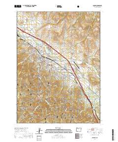
2020 Map of Ashland
USGS Topo · Published 2020About this map
The educational and institutional hub of Ashland centers around the Southern Oregon University campus and specialized facilities like the Clark R Bavin National Fish and Wildlife Forensics Laboratory. This 2020 map documents the city's complex interface between urban infrastructure and the steep topography of the Rogue River National Forest to the south. Water management is a primary theme of the landscape, traced through the Ashland Lateral and the storage at Reeder Reservoir. Genealogists will find significant detail in the distribution of local burial grounds, including the Ashland Cem, Meyers Cem, and Hargadine Cem. Further south, the map transitions into the Cascades, where the Lamb Mine and peaks like Winburn Mtn and Dunn Butte define the high country above Quartz Cr.
Find a feature on this map
160 named features on this map. Tap any name to fly to it.
Don’t see what you’re looking for? This feature index may not catch every label — zoom into the map to look around manually.
Map Details
Editions of this 2020 Ashland Map
This is the sole edition of this map. No revisions or reprints were ever made.
Other maps of this area

1891 · Ashland
USGS Topo · 1:250,000

1893 · Ashland
USGS Topo · 1:250,000

1897 · Ashland
USGS Topo · 1:250,000

1938 · Medford
USGS Topo · 1:125,000

1954 · Medford
USGS Topo · 1:62,500

1954 · Lakecreek
USGS Topo · 1:62,500

1954 · Talent
USGS Topo · 1:62,500

1954 · Ashland
USGS Topo · 1:62,500

1955 · Medford
USGS Topo · 1:250,000

1957 · Medford
USGS Topo · 1:250,000