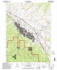
1996 Map of Ashland
USGS Topo · Published 1998About this map
Ashland sits at the nexus of the Siskiyou Mountains and the Bear Creek valley in this mid-1990s survey. The city's academic and cultural character is evident in the presence of Southern Oregon State College and the extensive Lithia Park that follows the lower reaches of Wrights Creek. To the south, the terrain rises sharply into the Rogue River National Forest, where the Reeder Reservoir serves as a critical mountain watershed fed by the East Fork and West Fork. Transport and industrial infrastructure, including the Southern Pacific railroad and Interstate 5, trace the valley floor alongside older landmarks like the Jackson Hot Springs. The map also captures local topographical curiosities like Pompadour Bluff and the family-named Miller Ranch, illustrating a landscape transitioning from the urban center to cattle ranching and protected timberlands.
Find a feature on this map
50 named features on this map. Tap any name to fly to it.
Don’t see what you’re looking for? This feature index may not catch every label — zoom into the map to look around manually.
Map Details
Editions of this 1996 Ashland Map
This is the sole edition of this map. No revisions or reprints were ever made.
Other maps of this area

1891 · Ashland
USGS Topo · 1:250,000

1893 · Ashland
USGS Topo · 1:250,000

1897 · Ashland
USGS Topo · 1:250,000

1938 · Medford
USGS Topo · 1:125,000

1954 · Medford
USGS Topo · 1:62,500

1954 · Lakecreek
USGS Topo · 1:62,500

1954 · Talent
USGS Topo · 1:62,500

1954 · Ashland
USGS Topo · 1:62,500

1955 · Medford
USGS Topo · 1:250,000

1957 · Medford
USGS Topo · 1:250,000