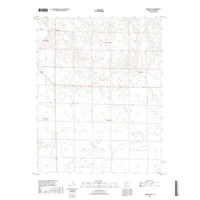
2018 Map of Ashland NW
USGS Topo · Published 2018About this map
Big Basin and Little Basin dominate the northwestern corner of this Kansas landscape, forming dramatic geological depressions in the High Plains. This Clark County terrain is defined by a series of north-south drainage systems, including Antelope Cr and Keiger Cr, which carve through the prairie. The map provides a clear look at the Public Land Survey System grid, highlighting township lines such as t32s r25w and t33s r24w. Human presence is marked by a network of county roads that follow the section lines, with Beckys Knob standing as a rare named elevation point in the eastern portion. The drainage patterns of Little Sandy Cr illustrate the localized erosion that shapes this part of the Cimarron River watershed, offering a detailed view of the rural geography in the late twenty-first century.
Find a feature on this map
23 named features on this map. Tap any name to fly to it.
Don’t see what you’re looking for? This feature index may not catch every label — zoom into the map to look around manually.
Map Details
Editions of this 2018 Ashland NW Map
This is the sole edition of this map. No revisions or reprints were ever made.
Other maps of this area

1892 · Meade
USGS Topo · 1:125,000

1896 · Ashland
USGS Topo · 1:125,000

1955 · Pratt
USGS Topo · 1:250,000

1955 · Dodge City
USGS Topo · 1:250,000

1958 · Dodge City
USGS Topo · 1:250,000

1959 · Pratt
USGS Topo · 1:250,000

1959 · Dodge City
USGS Topo · 1:250,000

1967 · Fowler SE
USGS Topo · 1:24,000

1972 · Ashland NW
USGS Topo · 1:24,000
1972 · Proffitt Lake
USGS Topo · 1:24,000