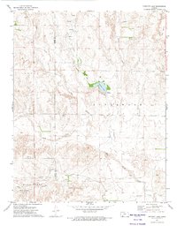
1972 Map of Proffitt Lake
USGS Topo · Published 1974About this map
Old Indian Treaty Boundary runs vertically through this part of the Kansas prairie, marking a historical line of demarcation across the landscape. The terrain is defined by a series of drainage systems, including Gyp Creek, Johns Creek, and Indian Creek, which converge as they flow south toward the Sand Creek area. In the northeast corner, the notable geological depression of Big Basin stands out against the surrounding topography, while Proffitt Lake provides a central water feature with an adjacent Caliche Pit and Spring. Traces of early rural life and industrial activity appear in the form of isolated Grave sites, a Gas Well, and the confluence of Big Sandy Creek and Twomile Creek. This 1972 survey illustrates the sparse settlement and agricultural character of the borderlands between Meade and Clark Counties.
Find a feature on this map
18 named features on this map. Tap any name to fly to it.
Don’t see what you’re looking for? This feature index may not catch every label — zoom into the map to look around manually.
Map Details
Editions of this 1972 Proffitt Lake Map
This is the sole edition of this map. No revisions or reprints were ever made.
Other maps of this area

1892 · Meade
USGS Topo · 1:125,000

1896 · Ashland
USGS Topo · 1:125,000

1955 · Pratt
USGS Topo · 1:250,000

1955 · Dodge City
USGS Topo · 1:250,000

1958 · Dodge City
USGS Topo · 1:250,000

1959 · Pratt
USGS Topo · 1:250,000

1959 · Dodge City
USGS Topo · 1:250,000

1967 · Fowler SE
USGS Topo · 1:24,000

1967 · Fowler SW
USGS Topo · 1:24,000

1972 · Ashland NW
USGS Topo · 1:24,000