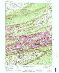
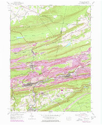
1953 Map of Ashland
USGS Topo · Published 1989About this map
The coal country of eastern Pennsylvania is defined here by the deep cuts and ridges of the Appalachian Mountains, where towns like Ashland and Girardville sit in the narrow valleys between Mahanoy Mountain and Broad Mountain. This specific survey shows Centralia before the onset of the mine fire that would eventually lead to its near-total relocation, with the neighboring settlement of Byrnesville and the Centralia Fire Tower clearly marked. The landscape is heavily marked by the region's industrial heritage, showing extensive mine dumps and mine dumps lining the hillsides above the Conrail lines that follow the course of Mahanoy Creek. Between the urban centers, family landmarks like Prezler and the Immaculate Heart Academy near Fountain Springs offer specific points of interest for local historians and genealogists tracing the social and physical geography of the mid-20th-century coal region.
Find a feature on this map
40 named features on this map. Tap any name to fly to it.
Don’t see what you’re looking for? This feature index may not catch every label — zoom into the map to look around manually.
Map Details
Editions of this 1953 Ashland Map
5 editions found
Other maps of this area

1889 · Catawissa
USGS Topo · 1:62,500

1889 · Pottsville
USGS Topo · 1:62,500

1891 · Pottsville
USGS Topo · 1:62,500

1892 · Catawissa
USGS Topo · 1:62,500

1892 · Mahanoy
USGS Topo · 1:62,500

1892 · Pine Grove
USGS Topo · 1:62,500

1893 · Mahanoy
USGS Topo · 1:62,500

1894 · Catawissa
USGS Topo · 1:62,500

1944 · Pottsville
USGS Topo · 1:24,000

1947 · Ashland
USGS Topo · 1:24,000