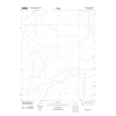
2012 Map of Ashland SE
USGS Topo · Published 2012About this map
The Cimarron River meanders across the southern portion of this Clark County landscape, defining the local drainage and topography in the early twenty-first century. This rural expanse is characterized by a dense network of watercourses that feed into the main river channel, including the prominent Big Sandy Cr and the uniquely named Stink Cr. The land is segmented by a strictly rectangular road grid, with local access provided by routes such as Angle Rd in the northwest and River Rd near the water's edge.
Find a feature on this map
12 named features on this map. Tap any name to fly to it.
Don’t see what you’re looking for? This feature index may not catch every label — zoom into the map to look around manually.
Map Details
Editions of this 2012 Ashland SE Map
This is the sole edition of this map. No revisions or reprints were ever made.
Other maps of this area

1894 · Sitka
USGS Topo · 1:62,500

1896 · Ashland
USGS Topo · 1:125,000

1955 · Woodward
USGS Topo · 1:250,000

1955 · Pratt
USGS Topo · 1:250,000

1958 · Woodward
USGS Topo · 1:250,000

1959 · Pratt
USGS Topo · 1:250,000

1970 · Buffalo NW
USGS Topo · 1:24,000
1970 · Rosston NW
USGS Topo · 1:24,000

1970 · Rosston NE
USGS Topo · 1:24,000

1972 · Ashland NW
USGS Topo · 1:24,000