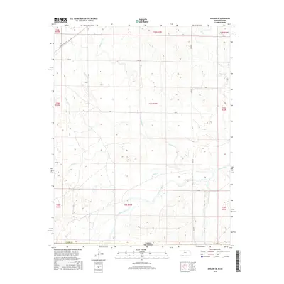
2016 Map of Ashland SE
USGS Topo · Published 2016About this map
The Cimarron River meanders across the southern landscape of this Clark County survey, defining the geography of the Kansas and Oklahoma borderlands. This region is characterized by a dense network of seasonal and perennial drainage systems, including Little Sandy Cr, Big Sandy Cr, and Bullard Cr, which carve through the plains. The map reveals a strictly organized section-line road grid, featuring routes like Acres Rd and River Rd, occasionally interrupted by the more diagonal path of the Shortgrass Prairie Trl in the northwest. This 2016 data illustrates a sparsely populated agricultural and ranching environment where the land is largely shaped by watercourses like Stink Cr and Keiger Cr rather than urban centers. The juxtaposition of modern county roads against the natural winding of the river and creeks provides a clear view of how land management follows the township and range system in this border territory.
Find a feature on this map
25 named features on this map. Tap any name to fly to it.
Don’t see what you’re looking for? This feature index may not catch every label — zoom into the map to look around manually.
Map Details
Editions of this 2016 Ashland SE Map
This is the sole edition of this map. No revisions or reprints were ever made.
Other maps of this area

1894 · Sitka
USGS Topo · 1:62,500

1896 · Ashland
USGS Topo · 1:125,000

1955 · Woodward
USGS Topo · 1:250,000

1955 · Pratt
USGS Topo · 1:250,000

1958 · Woodward
USGS Topo · 1:250,000

1959 · Pratt
USGS Topo · 1:250,000

1970 · Buffalo NW
USGS Topo · 1:24,000
1970 · Rosston NW
USGS Topo · 1:24,000

1970 · Rosston NE
USGS Topo · 1:24,000

1972 · Ashland NW
USGS Topo · 1:24,000