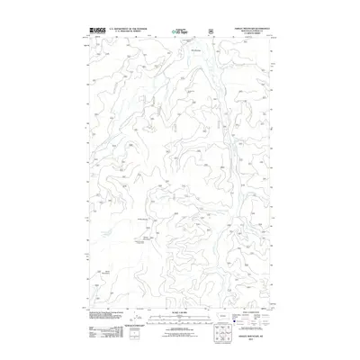
2011 Map of Ashley Mountain
USGS Topo · Published 2011About this map
Ashley Mountain dominates the southern skyline of this high-elevation landscape within the Salish Mountains, crowned by the Ashley Mountain Lookout Tower. The terrain is defined by a dense network of forest development roads, such as Natl Forest Develop Road 313 Rd, which trace the winding drainages of Logan Creek and Griffin Creek. Evidence of industrial history is found at the Copper King Mine, situated just south of the expansive Star Meadow. This area highlights the transition from traditional ranching operations at Star Meadow Ranch to timber management and resource extraction. Significant water features include the secluded Lupine Lake and the high ridge of the Ashley Divide, which partitions the local watersheds.
Find a feature on this map
24 named features on this map. Tap any name to fly to it.
Don’t see what you’re looking for? This feature index may not catch every label — zoom into the map to look around manually.
Map Details
Editions of this 2011 Ashley Mountain Map
This is the sole edition of this map. No revisions or reprints were ever made.
Other maps of this area

1957 · Kalispell
USGS Topo · 1:250,000

1960 · Kalispell
USGS Topo · 1:250,000

1961 · Kalispell
USGS Topo · 1:250,000

1962 · Johnson Peak
USGS Topo · 1:24,000

1962 · Lost Creek Divide
USGS Topo · 1:24,000

1962 · Ashley Mountain
USGS Topo · 1:24,000
1962 · Tally Lake
USGS Topo · 1:24,000

1963 · Sylvia Lake
USGS Topo · 1:24,000
1963 · Dunsire Point
USGS Topo · 1:24,000
1964 · Lone Lake
USGS Topo · 1:24,000