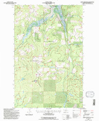
1994 Map of Ashley Mountain
USGS Topo · Published 1997About this map
The Flathead National Forest defines this high-elevation landscape, where the rugged terrain is carved by a complex network of waterways feeding into the Ashley Divide. Notable for its remote character, the area includes the prominent Ashley Mountain and several alpine features such as Lupine Lake. The presence of Mines near Sullivan Creek indicates a history of mineral exploration tucked into these drainages, while the Star Meadow Ranch in the north suggests localized agricultural or recreational operations amidst the timber. A web of forest roads traces the steep contours, connecting Meadow Creek to Griffin Creek, revealing how the timber and mining industries managed this backcountry long after initial aerial surveys in the 1950s.
Find a feature on this map
16 named features on this map. Tap any name to fly to it.
Don’t see what you’re looking for? This feature index may not catch every label — zoom into the map to look around manually.
Map Details
Editions of this 1994 Ashley Mountain Map
This is the sole edition of this map. No revisions or reprints were ever made.
Other maps of this area

1957 · Kalispell
USGS Topo · 1:250,000

1960 · Kalispell
USGS Topo · 1:250,000

1961 · Kalispell
USGS Topo · 1:250,000

1962 · Johnson Peak
USGS Topo · 1:24,000

1962 · Lost Creek Divide
USGS Topo · 1:24,000

1962 · Ashley Mountain
USGS Topo · 1:24,000
1962 · Tally Lake
USGS Topo · 1:24,000

1963 · Sylvia Lake
USGS Topo · 1:24,000
1963 · Dunsire Point
USGS Topo · 1:24,000
1964 · Lone Lake
USGS Topo · 1:24,000