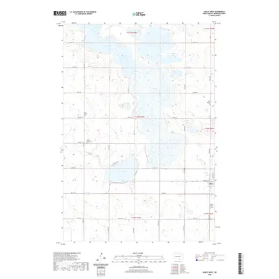
2020 Map of Ashley West
USGS Topo · Published 2020About this map
The town of Ashley anchors the eastern edge of this McIntosh County landscape, situated just south of the sprawling Dry Lake basin. This region is characterized by a dense concentration of glacial prairie potholes and larger water bodies, including Goose Lake to the north and Lake Hoskins to the west. The local infrastructure follows a rigid grid of section lines, with routes like W Main St and 48th Ave SE connecting the town to the surrounding agricultural prairie. Genealogists and local historians will find significant detail in the numerous community landmarks that dot the countryside. These include several distinct burial grounds such as the Beth Itzchock Cem, Trinity Lutheran Cem, Ashley Lutheran Cem, and the Hoskins Community Cem. The proximity of these sites to Lake Hoskins suggests the early footprint of settlement in this part of North Dakota before the town center solidified in its current location.
Find a feature on this map
34 named features on this map. Tap any name to fly to it.
Don’t see what you’re looking for? This feature index may not catch every label — zoom into the map to look around manually.
Map Details
Editions of this 2020 Ashley West Map
This is the sole edition of this map. No revisions or reprints were ever made.
Other maps of this area

1953 · Jamestown
USGS Topo · 1:250,000

1954 · Aberdeen
USGS Topo · 1:250,000

1956 · Aberdeen
USGS Topo · 1:250,000

1956 · Jamestown
USGS Topo · 1:250,000

1978 · Wolff Lake
USGS Topo · 1:24,000

1978 · Venturia
USGS Topo · 1:24,000

1978 · Schumacher Lake NE
USGS Topo · 1:24,000

1982 · Danzig
USGS Topo · 1:24,000

1982 · Ashley East
USGS Topo · 1:24,000

1982 · May Lake
USGS Topo · 1:24,000