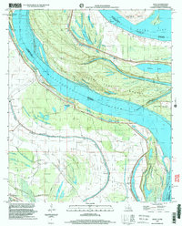
1998 Map of Ashly
USGS Topo · Published 2003About this map
The Mississippi River dominates this landscape along the Louisiana-Mississippi border, where complex fluvial patterns define the terrain of Madison Parish and Warren County. The intricate network of waterways including Halpino Lake, Eagle Lake, and Home Chute reflects the dynamic history of the river’s path, carved around landforms like Australia Island and Paw Paw Island. The map records a distinct rural social geography through its numerous country churches, such as Jerusalem Ch, St John Ch, and New Mt Zion Ch, which often served as the anchors for small communities like Ashly and Peelers. Protective infrastructure is prominent, with an extensive Levee system guarding the interior from the river's power. A notable historical site, the Cabin-Teele Crevasse, serves as a permanent record of the river's capacity to breach these defenses and reshape the local topography.
Find a feature on this map
33 named features on this map. Tap any name to fly to it.
Don’t see what you’re looking for? This feature index may not catch every label — zoom into the map to look around manually.
Map Details
Editions of this 1998 Ashly Map
This is the sole edition of this map. No revisions or reprints were ever made.
Other maps of this area

1909 · Millikens Bend
USGS Topo · 1:24,000

1909 · Tallulah
USGS Topo · 1:24,000

1909 · Mound
USGS Topo · 1:24,000

1910 · Mound
USGS Topo · 1:31,680

1918 · Vicksburg
USGS Topo · 1:62,500

1939 · Onward
USGS Topo · 1:62,500

1939 · Talla Bena
USGS Topo · 1:62,500

1939 · Alsatia
USGS Topo · 1:62,500

1941 · Vicksburg
USGS Topo · 1:62,500

1955 · Jackson
USGS Topo · 1:250,000