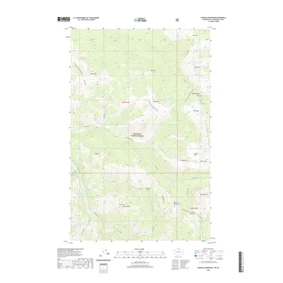
2020 Map of Ashnola Mountain
USGS Topo · Published 2020About this map
Okanogan National Forest dominates this high-elevation landscape in northern Washington, centered on the prominent peak of Ashnola Mtn. This terrain is defined by a series of steep ridges and glacial basins, including Whistler Basin and Sand Ridge. The drainage patterns are clearly visible, with the E Fork Pasayten River carving through the center of the sheet, fed by smaller tributaries like Stub Creek and Deception Cr. The presence of the Pacific NW National Scenic Trail provides a continuous north-south corridor for navigating this wilderness, passing near features like Bunker Hill and Quartz Mtn. At the southern edge, a chain of water bodies including Hidden Lakes, First Hidden Lake, and Cougar Lake lie tucked beneath the high summits of Tatoosh Buttes and Mid Mtn, illustrating the complex hydrology of the Pasayten Wilderness area.
Find a feature on this map
60 named features on this map. Tap any name to fly to it.
Don’t see what you’re looking for? This feature index may not catch every label — zoom into the map to look around manually.
Map Details
Editions of this 2020 Ashnola Mountain Map
This is the sole edition of this map. No revisions or reprints were ever made.
Other maps of this area

1920 · Slate Pass
USGS Topo · 1:125,000

1955 · Concrete
USGS Topo · 1:250,000

1958 · Concrete
USGS Topo · 1:250,000

1962 · Concrete
USGS Topo · 1:250,000

1969 · Lost Peak
USGS Topo · 1:24,000
1969 · Ashnola Mtn
USGS Topo · 1:24,000

1969 · Tatoosh Buttes
USGS Topo · 1:24,000

1969 · Billy Goat Mtn
USGS Topo · 1:24,000

1969 · Ashnola Pass
USGS Topo · 1:24,000
1969 · Mount Lago
USGS Topo · 1:24,000