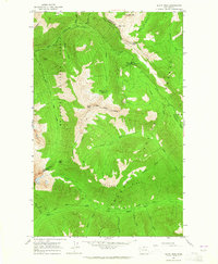
1969 Map of Mount Lago
USGS Topo · Published 1973About this map
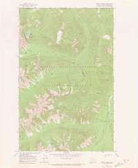
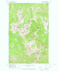
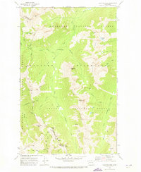
The high peaks of the Cascade Range define this 1969 survey of the Okanogan National Forest, where steep ridgelines and glacial cirques harbor numerous alpine lakes. Mount Lago and Osceola Peak anchor the central topography, part of a high-elevation network of summits that includes Ptarmigan Peak and Mt Carru. This area, protected within the Pasayten Wilderness, is characterized by its lack of roads, instead relying on a system of Pack Trails that connect remote water bodies like Lake Doris, Ferguson Lake, and Lease Lake. The hydrology is dominated by the headwaters of the Middle Fork Pasayten River and the South Fork Pasayten River, which drain the northern slopes toward the Canadian border. Key navigational landmarks for early backcountry travel are noted at Butte Pass and Shellrock Pass, providing transit points through the high terrain between Eureka Creek and Monument Creek.
Find a feature on this map
35 named features on this map. Tap any name to fly to it.
Don’t see what you’re looking for? This feature index may not catch every label — zoom into the map to look around manually.
Map Details
Editions of this 1969 Mount Lago Map
This is the sole edition of this map. No revisions or reprints were ever made.
Other maps of this area

1920 · Slate Pass
USGS Topo · 1:125,000

1955 · Concrete
USGS Topo · 1:250,000

1958 · Concrete
USGS Topo · 1:250,000

1962 · Concrete
USGS Topo · 1:250,000
1962 · Mazama
USGS Topo · 1:62,500
1963 · Slate Peak
USGS Topo · 1:24,000
1963 · Robinson Mtn.
USGS Topo · 1:24,000
1969 · Frosty Creek
USGS Topo · 1:24,000
1969 · Lost Peak
USGS Topo · 1:24,000
1969 · Pasayten Peak
USGS Topo · 1:24,000