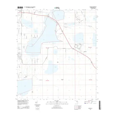
2015 Map of Ashton
USGS Topo · Published 2015About this map
Ashton and Harmony anchor a landscape defined by an intricate network of wetlands and freshwater basins in northern Osceola County. This area features a sequence of significant water bodies, including Lake Lizzie, Alligator Lake, and Lake Gentry, which are connected by a system of drainage patterns and marshy terrain marked by distinctive landforms such as Scrub Island and Sweet Bay Island. The settlement pattern follows the corridor of Highway 192 441, which bisects the quadrangle as it passes through the southern shore of Lake Lizzie. To the west, Gator Airpark serves as a local aviation landmark near the marshes of Lake Gentry. The map also details the evolving residential structure of Harmony, where street names like Beargrass Rd and Butterfly Dr reflect a planned community layout amidst the natural hydrology of Buck Lake and Pearl Lake.
Find a feature on this map
91 named features on this map. Tap any name to fly to it.
Don’t see what you’re looking for? This feature index may not catch every label — zoom into the map to look around manually.
Map Details
Editions of this 2015 Ashton Map
This is the sole edition of this map. No revisions or reprints were ever made.
Other maps of this area

1953 · Cypress Lake
USGS Topo · 1:24,000

1953 · Holopaw SE
USGS Topo · 1:24,000

1953 · Narcoossee SE
USGS Topo · 1:24,000

1953 · St Cloud North
USGS Topo · 1:24,000

1953 · Narcoossee
USGS Topo · 1:24,000

1953 · St Cloud South
USGS Topo · 1:24,000

1953 · Holopaw SW
USGS Topo · 1:24,000

1953 · Ashton
USGS Topo · 1:24,000

1953 · Holopaw
USGS Topo · 1:24,000

1955 · Orlando
USGS Topo · 1:250,000