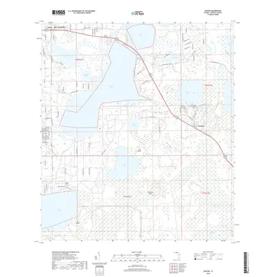
2018 Map of Ashton
USGS Topo · Published 2018About this map
Alligator Lake and its surrounding wetlands dominate this landscape south of St. Cloud in Osceola County. The map details a shifting environmental boundary where established settlements like Ashton and the more recently planned community of Harmony meet the expansive lake systems of the Kissimmee River basin. Notable water bodies including Lake Lizzie, Brick Lake, and Lake Gentry are interconnected by vast swampy margins such as Cat Island Swamp and Big Bend Swamp. This 2018 survey reveals the tension between modern suburban development and the low-lying terrain of the Florida interior, marked by named high points like Scrub Island and Sweet Bay Island that rise above the wetlands. Aviation interests are represented by the presence of Gator Airpark near the western shore of Lake Gentry, while the local road network, including Hickory Tree Rd and Co Rd 534, provides access to the scattered rural residences and lakeside tracts.
Find a feature on this map
90 named features on this map. Tap any name to fly to it.
Don’t see what you’re looking for? This feature index may not catch every label — zoom into the map to look around manually.
Map Details
Editions of this 2018 Ashton Map
This is the sole edition of this map. No revisions or reprints were ever made.
Other maps of this area

1953 · Cypress Lake
USGS Topo · 1:24,000

1953 · Holopaw SE
USGS Topo · 1:24,000

1953 · Narcoossee SE
USGS Topo · 1:24,000

1953 · St Cloud North
USGS Topo · 1:24,000

1953 · Narcoossee
USGS Topo · 1:24,000

1953 · St Cloud South
USGS Topo · 1:24,000

1953 · Holopaw SW
USGS Topo · 1:24,000

1953 · Ashton
USGS Topo · 1:24,000

1953 · Holopaw
USGS Topo · 1:24,000

1955 · Orlando
USGS Topo · 1:250,000