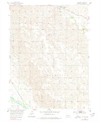
1953 Map of Ashton
USGS Topo · Published 1978About this map
The village of Ashton serves as the hub of this rural Sherman County landscape, situated along the Burlington and Quincy railroad line in the mid-1950s. The survey reveals a highly organized township system, where local education and community life are anchored by scattered landmarks like School No 26, School No 6, and the Immanuel Ch. The southern portion of the map is defined by the sweeping course of the Middle Loup River, which transitions the terrain from the dissected uplands near Ashton to the river valley floor. This area is a dual-railroad corridor, featuring both the Burlington and Quincy and the Union Pacific lines. Genealogists will find particular value in the placement of these rural schools and the Union Cem, while the drainage patterns of Oak Creek, Rock Creek, and Deer Creek illustrate the natural irrigation of this agricultural heartland during the development of the Missouri River Basin.
Find a feature on this map
18 named features on this map. Tap any name to fly to it.
Don’t see what you’re looking for? This feature index may not catch every label — zoom into the map to look around manually.
Map Details
Editions of this 1953 Ashton Map
2 editions found
Other maps of this area

1899 · Loup
USGS Topo · 1:125,000

1953 · Cotesfield
USGS Topo · 1:24,000

1953 · Rockville
USGS Topo · 1:24,000

1953 · Boelus
USGS Topo · 1:24,000

1953 · Ravenna NW
USGS Topo · 1:24,000

1953 · Loup City SE
USGS Topo · 1:24,000

1953 · Loup City
USGS Topo · 1:24,000

1953 · Farwell
USGS Topo · 1:24,000

1953 · Ashton
USGS Topo · 1:24,000

1953 · Ravenna
USGS Topo · 1:24,000