
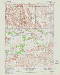
1953 Map of Boelus
USGS Topo · Published 1955About this map
The confluence of the Middle Loup River and South Loup River shapes this mid-century landscape in Howard County, Nebraska. At the heart of the river valley, Boelus (Howard City) serves as a primary hub, situated along the Union Pacific railroad line. This period of Missouri River Basin development is evidenced by the detailed mapping of water infrastructure, including a Power Plant and a Gaging Station positioned on the river's banks. To the south, the village of St Michael sits near the Chicago Burlington and Quincy tracks and Sweet Creek. The map reflects a deeply rooted rural community, documented through a high density of one-room schoolhouses like School No 58 and Boesen Sch, and local religious landmarks such as Dry Creek Ch and the Swedish Cem.
Find a feature on this map
27 named features on this map. Tap any name to fly to it.
Don’t see what you’re looking for? This feature index may not catch every label — zoom into the map to look around manually.
Map Details
Editions of this 1953 Boelus Map
2 editions found
Other maps of this area

1895 · Wood River
USGS Topo · 1:62,500

1896 · Wood River
USGS Topo · 1:125,000

1899 · Loup
USGS Topo · 1:125,000

1953 · Dannebrog
USGS Topo · 1:24,000

1953 · Rockville
USGS Topo · 1:24,000

1953 · Farwell
USGS Topo · 1:24,000

1953 · Nysted
USGS Topo · 1:24,000

1953 · Ashton
USGS Topo · 1:24,000

1955 · Broken Bow
USGS Topo · 1:250,000

1955 · Grand Island
USGS Topo · 1:250,000