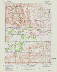
1953 Map of Boelus
USGS Topo · Published 1978About this map
Boelus (Howard City) serves as a primary hub of activity where the Union Pacific railroad tracks trace the northern bank of the Middle Loup River. This 1953 survey, updated with 1970s photogrammetric data, reveals a landscape organized by both water and rail, with the Burlington Northern line cutting through the southern portion near St Michael. The rural character of the region is punctuated by a network of one-room schoolhouses such as School No 25, Boesen Sch, and School No 58, reflecting the early 20th-century educational infrastructure of Central Nebraska.
Find a feature on this map
29 named features on this map. Tap any name to fly to it.
Don’t see what you’re looking for? This feature index may not catch every label — zoom into the map to look around manually.
Map Details
Editions of this 1953 Boelus Map
2 editions found
Other maps of this area

1895 · Wood River
USGS Topo · 1:62,500

1896 · Wood River
USGS Topo · 1:125,000

1899 · Loup
USGS Topo · 1:125,000

1953 · Dannebrog
USGS Topo · 1:24,000

1953 · Rockville
USGS Topo · 1:24,000

1953 · Boelus
USGS Topo · 1:24,000

1953 · Farwell
USGS Topo · 1:24,000

1953 · Nysted
USGS Topo · 1:24,000

1953 · Ashton
USGS Topo · 1:24,000

1955 · Broken Bow
USGS Topo · 1:250,000