
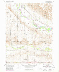
1953 Map of Rockville
USGS Topo · Published 1955About this map
Rockville sits as the primary rail-side settlement at the confluence of the Middle Loup River and Rock Creek, served by the Union Pacific line. This mid-century survey illustrates a landscape of established rural school districts and family landmarks across the Sherman and Buffalo County border. To the south, the Chicago Burlington and Quincy railroad follows the course of the South Loup River through Garfield and Cherry Creek townships. The map records several localized educational and burial sites essential for genealogical research, including the Coulter Sch, Nantasket Sch, and Pleasant View Sch, alongside the Hayestown Cem and Souleville Cem. The terrain is characterized by dissected uplands between the river valleys, dotted with numerous Windmills that reveal the era's reliance on groundwater for the agricultural economy.
Find a feature on this map
20 named features on this map. Tap any name to fly to it.
Don’t see what you’re looking for? This feature index may not catch every label — zoom into the map to look around manually.
Map Details
Editions of this 1953 Rockville Map
2 editions found
Other maps of this area

1895 · Wood River
USGS Topo · 1:62,500

1896 · Wood River
USGS Topo · 1:125,000

1899 · Loup
USGS Topo · 1:125,000

1953 · Boelus
USGS Topo · 1:24,000

1953 · Ravenna NW
USGS Topo · 1:24,000

1953 · Farwell
USGS Topo · 1:24,000

1953 · Ashton
USGS Topo · 1:24,000

1953 · Ravenna
USGS Topo · 1:24,000

1955 · Broken Bow
USGS Topo · 1:250,000

1955 · Grand Island
USGS Topo · 1:250,000