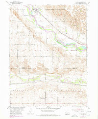
1953 Map of Rockville
USGS Topo · Published 1978About this map
Rockville sits at the northern edge of this Nebraska landscape, where the Union Pacific rail line follows the valley of the Middle Loup River. The area is defined by its agrarian social network, evidenced by the high density of rural schoolhouses and small cemeteries that once served the surrounding townships of Bristol and Rockville. This survey illustrates the transition from the river valley to the upland plains, where the South Loup River enters from the southwest. Local history is deeply embedded in the named school districts, including Coulter Sch, Nantasket Sch, and Pleasant View Sch, which reflect the distributed settlement pattern of the early to mid-20th century. The presence of both the Burlington Northern and Union Pacific railroads highlights the importance of rail transport in moving goods across the Sherman and Buffalo county line.
Find a feature on this map
19 named features on this map. Tap any name to fly to it.
Don’t see what you’re looking for? This feature index may not catch every label — zoom into the map to look around manually.
Map Details
Editions of this 1953 Rockville Map
2 editions found
Other maps of this area

1895 · Wood River
USGS Topo · 1:62,500

1896 · Wood River
USGS Topo · 1:125,000

1899 · Loup
USGS Topo · 1:125,000

1953 · Rockville
USGS Topo · 1:24,000

1953 · Boelus
USGS Topo · 1:24,000

1953 · Ravenna NW
USGS Topo · 1:24,000

1953 · Farwell
USGS Topo · 1:24,000

1953 · Ashton
USGS Topo · 1:24,000

1953 · Ravenna
USGS Topo · 1:24,000

1955 · Broken Bow
USGS Topo · 1:250,000