
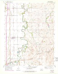
1955 Map of Assaria
USGS Topo · Published 1956About this map
The Smoky Hill River meanders sharply through the heart of Saline County in the mid-1950s, defining the agricultural and industrial character of the region. This survey highlights the critical intersection of water and rail transport, where the Union Pacific and Missouri Pacific lines parallel the river valleys. The settlement of Assaria sits as a primary hub along the tracks, while smaller locales like Mentor, Bridgeport, and Hallville provide a window into the rural township structures of Smolan, Walnut, Smoky View, and Liberty.
Find a feature on this map
21 named features on this map. Tap any name to fly to it.
Don’t see what you’re looking for? This feature index may not catch every label — zoom into the map to look around manually.
Map Details
Editions of this 1955 Assaria Map
2 editions found
Other maps of this area

1889 · Abilene
USGS Topo · 1:125,000

1892 · Salina
USGS Topo · 1:125,000

1894 · Abilene
USGS Topo · 1:125,000

1942 · Salina
USGS Topo · 1:125,000

1955 · Salina
USGS Topo · 1:24,000

1955 · Salina SW
USGS Topo · 1:24,000

1955 · Smolan
USGS Topo · 1:24,000

1955 · Kipp
USGS Topo · 1:24,000

1955 · Gypsum
USGS Topo · 1:24,000

1955 · Hutchinson
USGS Topo · 1:250,000