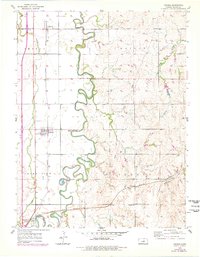
1955 Map of Assaria
USGS Topo · Published 1978About this map
The Smoky Hill River meanders across this Saline County landscape, creating a serpentine boundary between the agrarian townships of Smolan, Walnut, Smoky View, and Liberty. The mid-century rural infrastructure is defined by the heavy presence of the Union Pacific and Missouri Pacific railroads, which anchor the small settlements of Assaria, Mentor, and Bridgeport. While much of the area is dedicated to sprawling farmland, the map documents active resource extraction with several Oil Wells and a Substation near the river bend. Local education and community life are grounded by rural landmarks like the Summit Hill Sch near Summit Hill and the Wheeler Sch to the south. Small tributaries like Dry Creek and Spring Creek cut through the terrain, further shaping the development of these central Kansas communities during a period of infrastructure modernization.
Find a feature on this map
21 named features on this map. Tap any name to fly to it.
Don’t see what you’re looking for? This feature index may not catch every label — zoom into the map to look around manually.
Map Details
Editions of this 1955 Assaria Map
2 editions found
Other maps of this area

1889 · Abilene
USGS Topo · 1:125,000

1892 · Salina
USGS Topo · 1:125,000

1894 · Abilene
USGS Topo · 1:125,000

1942 · Salina
USGS Topo · 1:125,000

1955 · Salina
USGS Topo · 1:24,000

1955 · Assaria
USGS Topo · 1:24,000

1955 · Salina SW
USGS Topo · 1:24,000

1955 · Smolan
USGS Topo · 1:24,000

1955 · Kipp
USGS Topo · 1:24,000

1955 · Gypsum
USGS Topo · 1:24,000