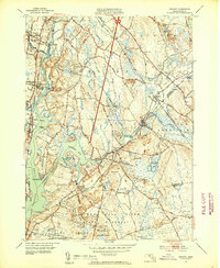
1951 Map of Assonet
USGS Topo · Published 1953About this map
The Taunton River and its winding tributaries dominate this mid-century portrait of Bristol County, where maritime geography meets a maturing inland infrastructure. The shoreline is punctuated by Assonet Bay and Shepherds Cove, providing a backdrop for established riverfront communities like Dighton and North Dighton. Further inland, the map captures the transition from small-town centers to the dense woodlands of the Freetown Fall River State Forest and the State Wildlife Sanctuary.
Find a feature on this map
59 named features on this map. Tap any name to fly to it.
Don’t see what you’re looking for? This feature index may not catch every label — zoom into the map to look around manually.
Map Details
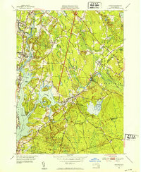
Editions of this 1951 Assonet Map
3 editions found

Other maps of this area

1885 · New Bedford
USGS Topo · 1:62,500

1885 · Middleboro
USGS Topo · 1:62,500

1885 · Taunton
USGS Topo · 1:62,500

1888 · New Bedford
USGS Topo · 1:62,500

1888 · Fall River
USGS Topo · 1:62,500

1888 · Taunton
USGS Topo · 1:62,500

1888 · Middleboro
USGS Topo · 1:62,500

1893 · Taunton
USGS Topo · 1:62,500

1893 · Middleboro
USGS Topo · 1:62,500

1893 · Fall River
USGS Topo · 1:62,500