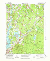
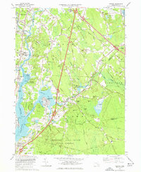
1977 Map of Assonet
USGS Topo · Published 1979About this map
The Taunton River and its intricate tributaries dominate this coastal landscape, where the tides meet the early industrial and agricultural heart of Bristol County. In the late 1970s, the area shows a complex transition between the urban fringes of Taunton and Fall River and the preserved woods of the Freetown Fall River State Forest. The river's historical importance is anchored by Dighton Rock State Park, preserving a famous petroglyph site across from the village of Dighton.
Find a feature on this map
83 named features on this map. Tap any name to fly to it.
Don’t see what you’re looking for? This feature index may not catch every label — zoom into the map to look around manually.
Map Details
Editions of this 1977 Assonet Map
3 editions found

Other maps of this area

1885 · New Bedford
USGS Topo · 1:62,500

1885 · Middleboro
USGS Topo · 1:62,500

1885 · Taunton
USGS Topo · 1:62,500

1888 · New Bedford
USGS Topo · 1:62,500

1888 · Fall River
USGS Topo · 1:62,500

1888 · Taunton
USGS Topo · 1:62,500

1888 · Middleboro
USGS Topo · 1:62,500

1893 · Taunton
USGS Topo · 1:62,500

1893 · Middleboro
USGS Topo · 1:62,500

1893 · Fall River
USGS Topo · 1:62,500