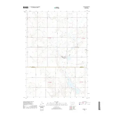
2017 Map of Astoria
USGS Topo · Published 2017About this map
Astoria sits upon the distinctive Coteau des Prairies, a vast plateau that dominates the topography of this eastern South Dakota landscape. The town plan is clearly defined by residential streets such as Norden St, Togstad St, and Boren St, serving as a central hub for the surrounding agricultural sections. The map reveals a high concentration of prairie wetlands and water features, most notably the expansive Oak Lake in the southern portion and the meandering Cobb Cr to the north. For those tracing local heritage, the inclusion of Bethany Cem and Bethlehem Cem provides precise locations for genealogical research. The transition between Deuel and Brookings counties is marked along 196th St, showing how the grid of section lines and county roads like Co Rd 517 organizes the movement across this glacial upland.
Find a feature on this map
28 named features on this map. Tap any name to fly to it.
Don’t see what you’re looking for? This feature index may not catch every label — zoom into the map to look around manually.
Map Details
Editions of this 2017 Astoria Map
This is the sole edition of this map. No revisions or reprints were ever made.
Other maps of this area

1953 · Watertown
USGS Topo · 1:250,000

1958 · Watertown
USGS Topo · 1:250,000

1967 · Canby NW
USGS Topo · 1:24,000

1967 · Lake Benton NW
USGS Topo · 1:24,000

1967 · Hendricks
USGS Topo · 1:24,000

1970 · Brandt
USGS Topo · 1:24,000

1970 · White NE
USGS Topo · 1:24,000

1970 · Astoria
USGS Topo · 1:24,000

1970 · White
USGS Topo · 1:24,000

1970 · Clear Lake South
USGS Topo · 1:24,000
Featured Places
- Astoria, SD
- Scandinavia Township, SD
- Lake Hendricks Township, SD
- Oaklake Township, SD
- Brookings County, SD