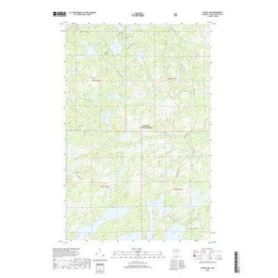
2019 Map of Astrid Lake
USGS Topo · Published 2019About this map
Superior National Forest encompasses this wilderness area in northeast St. Louis County, where a dense network of glacial lakes and portage-style trails defines the landscape. The hydrography is particularly complex, featuring large bodies such as Trout Lake and Little Trout Lake connected by the Little Trout-Sioux River. Smaller, more isolated waters like Astrid Lake, Maude Lake, and Lake Crellin are linked by a system of primitive paths including the Astrid Main Trail and several specialized spurs such as Maude Lake Spur B. The absence of developed highways is replaced by a web of forest access points like Zoom Road and the Norway Trail, reflecting the area's ongoing use for timber management and backcountry recreation. This contemporary survey documents the intricate drainage patterns of creeks like Hilda Cr and Nigh Creek that feed into the region's vast wetland ecosystems.
Find a feature on this map
42 named features on this map. Tap any name to fly to it.
Don’t see what you’re looking for? This feature index may not catch every label — zoom into the map to look around manually.
Map Details
Editions of this 2019 Astrid Lake Map
This is the sole edition of this map. No revisions or reprints were ever made.
Other maps of this area

1954 · Hibbing
USGS Topo · 1:250,000

1954 · International Falls
USGS Topo · 1:250,000

1956 · Sioux Pine Island
USGS Topo · 1:24,000

1956 · Vermilion Dam
USGS Topo · 1:24,000

1956 · Chad Lake
USGS Topo · 1:24,000

1957 · Hibbing
USGS Topo · 1:250,000

1957 · International Falls
USGS Topo · 1:250,000

1958 · International Falls
USGS Topo · 1:250,000

1958 · Hibbing
USGS Topo · 1:250,000

1963 · Echo Lake
USGS Topo · 1:24,000