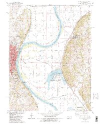
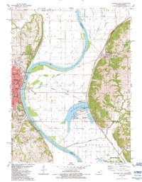
1984 Map of Atchison East
USGS Topo · Published 1984About this map
The Missouri River forms a complex boundary here, snaking through wide bends like Mc Queen Bend and Rushville Bend that define the state line between Kansas and Missouri. On the Kansas side, the city of Atchison serves as a significant hub, featuring the Benedictine College (North Campus) and South Campus, alongside various local institutions like Trinity Sch and St Joseph Sch. Across the water, the Missouri landscape is marked by the low-lying Lewis and Clark Lake and the State Fish Hatchery, reflecting the river's influence on local industry and conservation.
Find a feature on this map
67 named features on this map. Tap any name to fly to it.
Don’t see what you’re looking for? This feature index may not catch every label — zoom into the map to look around manually.
Map Details
Editions of this 1984 Atchison East Map
2 editions found
Other maps of this area

1885 · Atchison
USGS Topo · 1:125,000

1886 · Oskaloosa
USGS Topo · 1:125,000

1888 · Oskaloosa
USGS Topo · 1:125,000

1888 · Atchison
USGS Topo · 1:125,000

1890 · Kansas City
USGS Topo · 1:125,000

1893 · Atchison
USGS Topo · 1:125,000

1894 · Kansas City
USGS Topo · 1:125,000

1894 · Oskaloosa
USGS Topo · 1:125,000

1910 · Leavenworth
USGS Topo · 1:62,500

1926 · Atchison
USGS Topo · 1:62,500