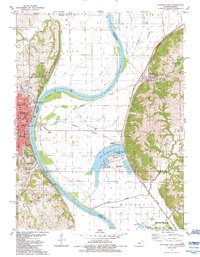
1984 Map of Atchison East
USGS Topo · Published 1984About this map
The Missouri River carves a wide path through this borderland, separating the city of Atchison in Kansas from the oxbow lakes and wetlands of Missouri. In the early 1980s, the river landscape is defined by its dramatic curves, most notably at Mc Queen Bend, and the industrial and educational presence in Atchison. Here, the dual campuses of Benedictine College anchor the riverbank, while the city's infrastructure is detailed through its Waterworks, Po, and several schools including St Benedict Sch and Martin West Sch.
Find a feature on this map
64 named features on this map. Tap any name to fly to it.
Don’t see what you’re looking for? This feature index may not catch every label — zoom into the map to look around manually.
Map Details
Editions of this 1984 Atchison East Map
2 editions found
Other maps of this area

1885 · Atchison
USGS Topo · 1:125,000

1886 · Oskaloosa
USGS Topo · 1:125,000

1888 · Oskaloosa
USGS Topo · 1:125,000

1888 · Atchison
USGS Topo · 1:125,000

1890 · Kansas City
USGS Topo · 1:125,000

1893 · Atchison
USGS Topo · 1:125,000

1894 · Kansas City
USGS Topo · 1:125,000

1894 · Oskaloosa
USGS Topo · 1:125,000

1910 · Leavenworth
USGS Topo · 1:62,500

1926 · Atchison
USGS Topo · 1:62,500