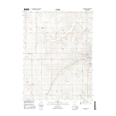
2016 Map of Atchison West
USGS Topo · Published 2016About this map
Atchison anchors the eastern edge of this landscape, where the Missouri River bluffs meet the agricultural uplands of Northeast Kansas. The western outskirts and surrounding townships are dotted with small rural nodes like Good Intent, Shannon, and Parnell, each connected by a rigorous section-line road grid including St Louis Church Rd and Pawnee Rd. For genealogists, the map is particularly rich in cemetery locations, ranging from the large Oak Hill Cem and Mount Saint Scholastica Cem near the city center to more remote family or community plots like Alderson Cem and Camp Creek Cem. The terrain is defined by the drainage systems of White Clay Cr and Deer Cr, which create localized relief against the otherwise orderly survey blocks. Aviation history is noted by the presence of the Amelia Earhart Airport, a landmark honoring the famous aviator in her hometown vicinity.
Find a feature on this map
86 named features on this map. Tap any name to fly to it.
Don’t see what you’re looking for? This feature index may not catch every label — zoom into the map to look around manually.
Map Details
Editions of this 2016 Atchison West Map
This is the sole edition of this map. No revisions or reprints were ever made.
Other maps of this area

1885 · Atchison
USGS Topo · 1:125,000

1886 · Oskaloosa
USGS Topo · 1:125,000

1888 · Oskaloosa
USGS Topo · 1:125,000

1888 · Atchison
USGS Topo · 1:125,000

1893 · Atchison
USGS Topo · 1:125,000

1894 · Oskaloosa
USGS Topo · 1:125,000

1926 · Atchison
USGS Topo · 1:62,500

1948 · Oak Mills
USGS Topo · 1:24,000

1950 · Kansas City
USGS Topo · 1:250,000
1951 · Oak Mills
USGS Topo · 1:24,000