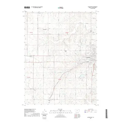
2018 Map of Atchison West
USGS Topo · Published 2018About this map
Atchison serves as the focal point of this northeastern Kansas landscape, where the western reaches of the city meet the rolling agricultural fields of the Missouri River valley. The area is characterized by a dense network of country roads, such as Pardee Rd and Neosho Rd, that connect scattered rural communities and family cemeteries. Significant aviation history is represented by the Amelia Earhart Airport, located north of the city center. Numerous watercourses, including White Clay Cr and Deer Cr, carve through the terrain, historically shaping the settlement patterns of towns like Good Intent and Shannon. For the genealogist, this map is particularly valuable for its documentation of many local burial grounds, ranging from Saint Louis Cem in the north to Camp Creek Cem in the south, reflecting the deep-rooted parish and community histories of Atchison County.
Find a feature on this map
81 named features on this map. Tap any name to fly to it.
Don’t see what you’re looking for? This feature index may not catch every label — zoom into the map to look around manually.
Map Details
Editions of this 2018 Atchison West Map
This is the sole edition of this map. No revisions or reprints were ever made.
Other maps of this area

1885 · Atchison
USGS Topo · 1:125,000

1886 · Oskaloosa
USGS Topo · 1:125,000

1888 · Oskaloosa
USGS Topo · 1:125,000

1888 · Atchison
USGS Topo · 1:125,000

1893 · Atchison
USGS Topo · 1:125,000

1894 · Oskaloosa
USGS Topo · 1:125,000

1926 · Atchison
USGS Topo · 1:62,500

1948 · Oak Mills
USGS Topo · 1:24,000

1950 · Kansas City
USGS Topo · 1:250,000
1951 · Oak Mills
USGS Topo · 1:24,000