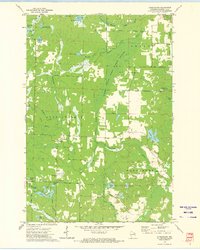
1972 Map of Athelstane
USGS Topo · Published 1975About this map
The Wausaukee River and South Branch Pike River dominate this Marinette County landscape, where water and conservation efforts define the terrain. The settlement of Athelstane serves as a local hub, supported by the nearby Athelstane Cem and the Assembly of God Ch. Evidence of the region's logging and transit history is visible in the long Old Railroad Grade and the Cedarville Lookout Tower standing watch over the forests.
Find a feature on this map
57 named features on this map. Tap any name to fly to it.
Don’t see what you’re looking for? This feature index may not catch every label — zoom into the map to look around manually.
Map Details
Editions of this 1972 Athelstane Map
This is the sole edition of this map. No revisions or reprints were ever made.
Other maps of this area

1939 · Pembine
USGS Topo · 1:48,000

1939 · Dunbar
USGS Topo · 1:48,000

1940 · Athelstane
USGS Topo · 1:48,000

1941 · Dunbar
USGS Topo · 1:48,000

1942 · Athelstane
USGS Topo · 1:48,000

1942 · Wausaukee
USGS Topo · 1:48,000

1947 · Pembine
USGS Topo · 1:48,000

1947 · Dunbar
USGS Topo · 1:48,000

1947 · Wausaukee
USGS Topo · 1:48,000

1954 · Iron Mountain
USGS Topo · 1:250,000