1988 Map of Athens
USGS Topo · Published 1988About this map
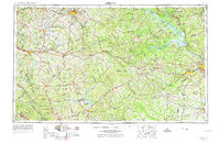
The Piedmont Plateau of eastern Georgia and western South Carolina is dominated by a complex network of major river basins and extensive man-made reservoirs. The Savannah River forms the state boundary, widening into the massive J Strom Thurmond Lake, while the Oconee River feeds into Lake Oconee and Lake Sinclair. These water features, alongside the expansive Oconee National Forest, define the landscape between the academic hub of Athens and the industrial and military center of Augusta.
Find a feature on this map
69 named features on this map. Tap any name to fly to it.
Don’t see what you’re looking for? This feature index may not catch every label — zoom into the map to look around manually.
Map Details
Editions of this 1988 Athens Map
This is the sole edition of this map. No revisions or reprints were ever made.
Historical Maps of Augusta Through Time
6 maps found