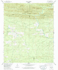
1980 Map of Athens
USGS Topo · Published 1986About this map
Athens serves as a central hub in this western Arkansas landscape, where the Little Missouri River carves through the southern reaches of the Cossatot Mountains. The terrain is defined by a series of prominent ridges, including Big Tom Mountain, Paul Mountain, and Brush Heap Mountain, much of which is protected within the Ouachita National Forest and the Caney Creek State Wildlife Management Area.
Find a feature on this map
37 named features on this map. Tap any name to fly to it.
Don’t see what you’re looking for? This feature index may not catch every label — zoom into the map to look around manually.
Map Details
Editions of this 1980 Athens Map
2 editions found
Other maps of this area

1906 · Caddo Gap
USGS Topo · 1:125,000

1913 · De Queen
USGS Topo · 1:125,000

1936 · Athens
USGS Topo · 1:48,000

1942 · Athens
USGS Topo · 1:62,500

1950 · Mcalester
USGS Topo · 1:250,000

1955 · Little Rock
USGS Topo · 1:250,000

1956 · Little Rock
USGS Topo · 1:250,000

1959 · Umpire
USGS Topo · 1:62,500

1960 · Little Rock
USGS Topo · 1:250,000

1962 · McAlester
USGS Topo · 1:250,000