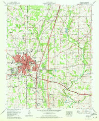
1967 Map of Athens
USGS Topo · Published 1972About this map
Athens serves as a thriving hub of education and transport in Limestone County during the late 1960s. The presence of Athens College, Athens Bible School, and a local High School highlights the city's role as a regional center of learning. The landscape is interconnected by the Louisville and Nashville railroad and major thoroughfares like Nashville Road and Browns Ferry Road, which connect the urban core to outlying residential developments such as Pinedale Acres and East Hampton.
Find a feature on this map
90 named features on this map. Tap any name to fly to it.
Don’t see what you’re looking for? This feature index may not catch every label — zoom into the map to look around manually.
Map Details
Editions of this 1967 Athens Map
3 editions found
Other maps of this area

1888 · Huntsville
USGS Topo · 1:125,000

1892 · Huntsville
USGS Topo · 1:125,000

1935 · Athens
USGS Topo · 1:24,000

1936 · Capshaw
USGS Topo · 1:24,000

1936 · Stewart Cross Roads
USGS Topo · 1:24,000

1936 · Elkmont
USGS Topo · 1:24,000

1936 · Ripley
USGS Topo · 1:24,000

1936 · Ardmore
USGS Topo · 1:24,000

1936 · Tanner
USGS Topo · 1:24,000

1936 · Greenbrier
USGS Topo · 1:24,000