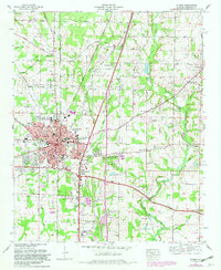
1967 Map of Athens
USGS Topo · Published 1982About this map
The Athens Corporate Boundary anchors this Tennessee Valley Authority study, revealing a regional hub transitioning from its agrarian roots into a postwar era of suburban expansion. The historic center of Athens is densely mapped, featuring the Athens College campus, the Courthouse, and the Louisville and Nashville Railroad corridor that historically drove the local economy. Beyond the city limits, a network of family-named landmarks and rural outposts like Sampson Chapel, Piney Chapel, and French Mill reflect a landscape defined by the watersheds of Swan Creek and Piney Creek.
Find a feature on this map
89 named features on this map. Tap any name to fly to it.
Don’t see what you’re looking for? This feature index may not catch every label — zoom into the map to look around manually.
Map Details
Editions of this 1967 Athens Map
3 editions found
Other maps of this area

1888 · Huntsville
USGS Topo · 1:125,000

1892 · Huntsville
USGS Topo · 1:125,000

1935 · Athens
USGS Topo · 1:24,000

1936 · Capshaw
USGS Topo · 1:24,000

1936 · Stewart Cross Roads
USGS Topo · 1:24,000

1936 · Elkmont
USGS Topo · 1:24,000

1936 · Ripley
USGS Topo · 1:24,000

1936 · Ardmore
USGS Topo · 1:24,000

1936 · Tanner
USGS Topo · 1:24,000

1936 · Greenbrier
USGS Topo · 1:24,000