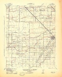
1942 Map of Athlone
USGS Topo · Published 1942About this map
The Chowchilla River and its intricate drainage network, including Ash Creek and Mariposa Slough, define this agricultural landscape during the early 1940s. The region is marked by a transition from large-scale holdings like Chowchilla Ranch and Bliss Ranch to more concentrated settlements along the Southern Pacific railroad corridor. The growing town of Chowchilla serves as a hub, while smaller stops such as Athlone, Minturn, and Legrand punctuate the rail line. A network of rural schools, including Savanna Sch and Ashview Sch, reflects the dispersed farming population of the time.
Find a feature on this map
51 named features on this map. Tap any name to fly to it.
Don’t see what you’re looking for? This feature index may not catch every label — zoom into the map to look around manually.
Map Details
Editions of this 1942 Athlone Map
This is the sole edition of this map. No revisions or reprints were ever made.
Other maps of this area

1913 · Panoche
USGS Topo · 1:125,000

1914 · Merced
USGS Topo · 1:31,680

1915 · Owens Creek
USGS Topo · 1:31,680

1916 · Berenda
USGS Topo · 1:31,680

1916 · Santa Rita Bridge
USGS Topo · 1:24,000

1917 · Merced
USGS Topo · 1:31,680

1918 · Bliss Ranch
USGS Topo · 1:31,680

1918 · Owens Creek
USGS Topo · 1:31,680

1918 · Lingard
USGS Topo · 1:31,680

1918 · Atwater
USGS Topo · 1:31,680