
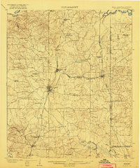
1910 Map of Atlanta
USGS Topo · Published 1910About this map
Atlanta and Queen City serve as the primary hubs in this early twentieth-century portrait of Northeast Texas, where the economy was driven by timber and agriculture. Numerous sawmills, including the Cass Lumber Co Sawmill and State Line Sawmill, are scattered along the creeks and rail lines, signaling a period of intensive lumber production. The landscape is crisscrossed by a dense network of transit, featuring the Texas and Pacific and the Kansas City Southern railroads, which facilitated the movement of goods across state lines. Along these routes, smaller communities like Springdale and Bloomburg provide a clear view of the rural settlement patterns before modern consolidation. Family and community life is deeply rooted in the land, evidenced by the high density of country churches such as Laws Chapel and Beulah Church, alongside local landmarks like Pritchards Gin and Hosey's Store that served as vital social and commercial gathering points.
Find a feature on this map
77 named features on this map. Tap any name to fly to it.
Don’t see what you’re looking for? This feature index may not catch every label — zoom into the map to look around manually.
Map Details
Editions of this 1910 Atlanta Map
2 editions found
Other maps of this area

1907 · Atlanta
USGS Topo · 1:62,500

1909 · New Boston
USGS Topo · 1:62,500

1909 · Texarkana
USGS Topo · 1:62,500

1910 · Linden
USGS Topo · 1:62,500

1932 · Hosston NW
USGS Topo · 1:31,680

1944 · Kildare
USGS Topo · 1:62,500

1948 · Kildare
USGS Topo · 1:62,500

1948 · Vivian
USGS Topo · 1:62,500

1952 · Doddridge NW
USGS Topo · 1:24,000

1952 · Doddridge
USGS Topo · 1:24,000