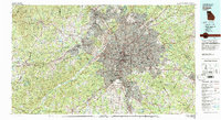
1981 Map of Atlanta
USGS Topo · Published 1982About this map
The Chattahoochee River carves a diagonal path through this 1981 snapshot of the Georgia Piedmont, separating the expanding urban core of Atlanta from the satellite communities of Cobb and Douglas counties. The map records a pivotal era of regional infrastructure, dominated by the massive footprint of the Hartsfield Atlanta International Airport and the completed loop of I-285. This beltway anchors a constellation of burgeoning suburbs like Sandy Springs, Smyrna, and Tucker, while the industrial and military backbone of the era is visible through Dobbins Air Force Base and Fort McPherson Military Reservation.
Find a feature on this map
86 named features on this map. Tap any name to fly to it.
Don’t see what you’re looking for? This feature index may not catch every label — zoom into the map to look around manually.
Map Details
Editions of this 1981 Atlanta Map
This is the sole edition of this map. No revisions or reprints were ever made.
Other maps of this area

1886 · Rome
USGS Topo · 1:125,000

1888 · Atlanta
USGS Topo · 1:125,000

1889 · Tallapoosa
USGS Topo · 1:125,000

1890 · Suwanee
USGS Topo · 1:125,000

1890 · Cartersville
USGS Topo · 1:125,000

1890 · Atlanta
USGS Topo · 1:125,000

1891 · Marietta
USGS Topo · 1:125,000

1891 · Gainesville
USGS Topo · 1:125,000

1891 · Cartersville
USGS Topo · 1:125,000

1892 · Tallapoosa
USGS Topo · 1:125,000