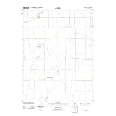
2011 Map of Atlanta
USGS Topo · Published 2011About this map
Atlanta sits at the northern edge of this Phelps County landscape, defined by a rigid grid of rural roads and an extensive network of water management features. The settlement is anchored by the Atlanta Post Office, serving a region where the natural drainage of Turkey Creek and School Creek has been augmented by numerous private and agricultural impoundments. These reservoirs, including the Peterson North Reservoir, Peterson South Reservoir, and McDonald Reservoir, illustrate the critical importance of water storage for the local agricultural economy. Further south, the Carter-David West Reservoir and Carter-David East Reservoir sit alongside Milrose Creek, while Einspahr Reservoir marks the lower reaches of the map. This distribution of family-named dams and reservoirs reveals a landscape deeply modified for irrigation and livestock, where named waterways like Flag Creek and Foster Creek provide the framework for a highly engineered prairie environment.
Find a feature on this map
26 named features on this map. Tap any name to fly to it.
Don’t see what you’re looking for? This feature index may not catch every label — zoom into the map to look around manually.
Map Details
Editions of this 2011 Atlanta Map
This is the sole edition of this map. No revisions or reprints were ever made.
Other maps of this area

1896 · Holdrege
USGS Topo · 1:125,000

1896 · Arapahoe
USGS Topo · 1:125,000

1898 · Arapahoe
USGS Topo · 1:125,000

1955 · Grand Island
USGS Topo · 1:250,000

1957 · Grand Island
USGS Topo · 1:250,000

1958 · Grand Island
USGS Topo · 1:250,000

1958 · Stamford
USGS Topo · 1:24,000

1958 · Mascot
USGS Topo · 1:24,000

1970 · Holdrege East
USGS Topo · 1:24,000
1970 · Loomis
USGS Topo · 1:24,000