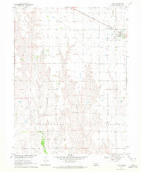
1970 Map of Loomis
USGS Topo · Published 1972About this map
The town of Loomis serves as the primary hub in this central Nebraska survey, situated along the Burlington Northern railroad corridor. The landscape is defined by the transition from the flat agricultural plains of the Laird and Union townships into the more dissected drainage basins of Rock Falls and Industry to the south. Spring Creek and Elm Creek carve distinctive patterns through the terrain, illustrating the natural erosion of the Loess Plains. Local history is anchored by the Shaw Cem, a vital landmark for genealogical research. The map also documents modern infrastructure of the era, including a major Pipeline crossing the territory and the Sewage Disposal Ponds just west of the village center, reflecting the technical development of the Missouri River Basin during the late twentieth century.
Find a feature on this map
11 named features on this map. Tap any name to fly to it.
Don’t see what you’re looking for? This feature index may not catch every label — zoom into the map to look around manually.
Map Details
Editions of this 1970 Loomis Map
This is the sole edition of this map. No revisions or reprints were ever made.
Other maps of this area

1896 · Lexington
USGS Topo · 1:125,000

1896 · Holdrege
USGS Topo · 1:125,000

1896 · Kearney
USGS Topo · 1:125,000

1896 · Arapahoe
USGS Topo · 1:125,000

1898 · Arapahoe
USGS Topo · 1:125,000

1899 · Lexington
USGS Topo · 1:125,000

1955 · Grand Island
USGS Topo · 1:250,000

1957 · Grand Island
USGS Topo · 1:250,000

1958 · Grand Island
USGS Topo · 1:250,000

1958 · Mascot
USGS Topo · 1:24,000